Ireland Creek in Lyell Canyon
Happy IsleからTuolumneまでは、Sunrise Creekがある程度で、通常は簡単に渡渉できる。ちょっと嫌なのは、Lyell CanyonのIreland Creekを渡る時だろう。幅は2-3メーターだが、流れが強い。写真のようにlog bridgeがある時もあるが、ないと思いきって水に入るしかない。
There is no difficult river crossing from Happy Isle to Tuolumne. Sunrise Creek is usually shallow and easy to cross. Ireland Creek in Lyell Canyon is a little difficult. The width is 2- 3 meters, but the stream is fast. There may be a kind of log bridge. When there is no log bridge, you must jump into the water. It is not comfortable.

Ireland Creek in Lyell Canyon

2011.07.31
Lyell Head Water
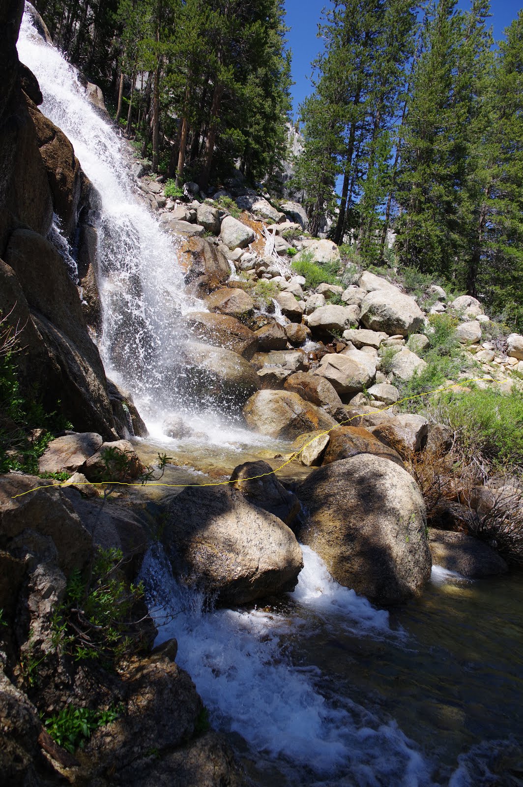
ライエル・フォーク最上流にはキャンプサイトがあり、渡渉箇所が続く。水量が少なければ、飛び石づたいに渡れるが、水量が多いと、靴を濡らしてしまう。写真の2009年は水量が少ない時、2011年は雪が残り、水量が多かった。渡渉の必要を感じなかったので、手前にテントを張って、翌朝を待った。
There is a campsite at the headwater of Lyell Fork and the river crossing adjacent to the site. When the water level is low, the river crossing is easily done by using the boulders. But when the water level is high, it is difficult to cross without getting wet. The 2009 photo indicates the low level of water and the 2011 photo indicates the high level of water since lots of snow remained. I pitched the tent near the crossing point.
アメリカ人ハイカーが果敢に川幅の広い所を渡渉したが、お腹か胸にまで水が来た。この川の川幅の広い部分は池のように深い。それで渡ってはいけない。翌朝は15センチほど水位が下がった。足を濡らすことなく、飛び石づたいに渡れた。ここでカメラをダメにしたという別のハイカーにも会った。
An American hiker challenged the crossing at the wide place of the river. But the water came at his stomach or chest. The wide part of the fork is deep as a lake. Therefore I do not recommend to cross the wide place. The water level lessened around 15 cm the next morning. Then I could cross the fork using boulders without wetting my boots. I met another hiker who broke his camera here.
地形図と2017年の写真をみれば渡渉を避けるルートは一目瞭然である。川の周りは歩けないほどの急斜面ではない。水位の高い場合は、写真の黄色の線のように歩くこと。そうすれば、足を濡らさずに済む。
The topological map and the 2018 photo suggested the safest route for avoiding river crossing clearly. The bank of the river is not steep. I recommend walking following the yellow line in the 2018 photo. Then you can cross the river without wet boots.


2009.08.01

2011.07.31

2017.08.17
Rush Creek
Rush Creekを渡ったのは何時も8月で、log bridgeが渡れないほど増水したのを見たことがない。2018年も確認を怠った。この地図の右にはMarie Lakesというきれいな湖があるが、行きそびれたままである。なお、Seldon Pass近くの湖はMarie Lakeと単数形である。
I always crossed Rush Creek in August, never seen the water too high to cross. I did not check the cross country route. There are beautiful lakes named Marie Lakes on the left side of this map. I did not hike yet. BTW, the beautiful lake near Seldon Pass is Marie Lake.
北からアプローチすると、HalfMileのマップでWA0927Bという湖が目印になる。この手前からクロスカントリーして高度を少し上げるとRush Creekの上流部に突き当たる。浅い所を選んで渡渉すると、Rush Creek Trailに合流する。下るとRush Creekのlog bridgeがある。このあたりで何度か休憩してランチを食べた記憶がある。
If you approach this area from the north, you will find a small lake WA0297B by HalfMile's map. The cross country begins near here and you will go a little higher place. Then you will find the upper stream of Rush Creek. Cross the shallow place, then there is Rush Creek Trail. If you hike along this trail, there is a log bridge of Rush Creek. I had lunch here a few times.


WA0927B

The log bridge of Rush Creek 2011.8.01
Silver Pass Creek/North Fork Mono Creek
Silver Passの南、Silver Pass Creekの渡渉は雪融け水の多い時は困難となる。2017年の6-7月は水量が多く、渡渉が困難であった。そこで、VVRに集結したPCTハイカーはSilver Pass Creekを完全に迂回し、Silver Passでなく、Goodale Passを越えて北上した。このコースは後述する。
The river crossing of Silver Pass Creek which located in the south of Silver Pass is difficult when the water level is high. It was extremely difficult in June and July of 2017. The majority of PCT hikers gathered at VVR were headed to Goodale Pass avoiding Silver Pass Creek and Silver Pass. I will describe this route later.
Silver Pass CreekとNorth Fork Mono Creekの渡渉箇所で大きな場所は地図の3箇所である。この中では上流部の1が一番危険である。夏の水量の乏しい時の写真を2枚示す。トレイルは黄色の線のように滝の下を横切っている。2枚目はトレイルのすぐ上の滝の写真である。
There are three crossings along Silver Pass Creek and North Fork Mono Creek as indicated on the map. The upper stream No.1 is the most dangerous. I will show you two photos when the water level was low.
この場所は増水時に渡渉が非常に危険である。迂回するにしても急勾配の崖をよじ登る必要があり、安全とは言えない。したがって、Silver Pass Creekの水量が多く危険という情報を得たら、コース変更してGoodale Passを目指すべきである。
The crossing point becomes very dangerous when the water level is high. If you want to avoid the crossing here, you must climb the steep terrain. It is not safe. Therefore, when you get the information that the water level of Silver Pass Creek is high, you should head to Goodale Pass, not to Silver Pass.

2017.08.12

2011.08.05

2018.08.08, dry year
Goodale Pass ( bypass the river crossing of Mono Creek )
Silver Passの代わりにGoodale Passを目指せば、Mono Creekの渡渉はない。2012年の夏はドライで、レイク・エディソンが干上がった。逆のケースである。そこで、Goodale Passを目指した。When you head to Goodale Pass instead of Silver Pass, you can avoid the crossing of Mono Creek. Contrarily, the summer of 2012 was completely dry and Lake Edison was dried up. Then I headed to Goodale Pass.
ルートは明瞭で、分岐には標識があり、しばらく登るとLake of Lone Indianという湖がある。その先はPassを越えるまで、ドライで水はない。Passの南のUpper Graveyard Meadowからは小川沿いに緩やかに下って行く。小川はあるが、渡渉は簡単である。VVRが近づくと、やはり標識があり、それに従うだけである。
The trail is clear. there was a sign at the junction. After ascending for a while, there is a lake named Lone Indian. There is no water beyond the pass. The trail descends gently from the Pass along a brook. The crossing of it is very easy. There are signs of VVR near Lake Edison. You can easily get to VVR.


The junction of Goodale Pass

Lake of Lone Indian

The trail toward the Pass

The trail toward the Pass

Goodale Pass

Upper Graveyard Meadow

Lake Edison 2012.08.07
Hilgard Branch
JMTはBear Creek沿いに上流に向かうが、Lake Italy への分岐、Hilgard Branchに渡渉箇所がある。深くはないが、水量が多い場合は飛び石が水面下に隠れる。この近くにテントサイトもある。
JMT goes along the upstream of Bear Creek. There is a crossing point at Hilgard Branch, which is the junction of Lake Italy. It is usually shallow and can cross using boulders. But when the water level is high, the boulders lie under the water. There are several tent sites here.


2010.08.10
Bear Creek
Bear Creekの通常の渡渉点は馬向きで、人間には向いていない。非常に水量の少ない時(2012年8月)は飛び石を利用して渡れたが、一般的に深く、水量が多いので、危険である。
The usual crossing point of Bear Creek is for horses, not for humans. When the water level is very low ( the summer of 2012 ), I crossed here using boulders. But, it is usually deep, then it is dangerous.
回避ルートは二つある。一つはEast Fork Bear Creekを少し遡って、渡渉してJMTに復帰するルートである。ここは確認していないが、クロスカントリーは容易な場所である。
There are two routes avoiding the dangerous crossing. One way is to hike along the East Fork Bear Creek, then cross the creek, and do a little cross country to JMT. I did not check this crossing, but cross country is easy.
もう一つは、通常渡渉点の300meterほど下流である。ここは川が二つに分かれていて、水深も浅い。地形図を検討して、準備してから臨んだ。2017年にはたまたまlog bridgeがいくつかあったので、靴を濡らさずに渡れた。なお、このlog bridgeは2018年に失われた。
Another way is to cross the 300 meters downstream of the usual crossing point. The creek is divided into two streams and shallow. I prepared the topological map in the 2017 summer beforehand. There were accidentally several log bridges at the small island. Therefore, I could cross without wetting my boots. BTW, these log bridges were washed out in 2018.


Bear Creek, the usual crossing point
Evolution Creek
Evolution Creekの渡渉は有名で、常に相当の水量がある。何時も通常の渡渉箇所を渡っていたが、2018年8月1日に確認のためもう一つのルートを歩いた。北向きJMTだったが、方向を逆転して説明する。The fording of Evolution Creek is famous. Its water level is constantly high. I had always crossed the usual crossing point. But I had to check the alternative route. Therefore I walked here as NOBO JMT. I describe it reversely.
通常渡渉箇所は最初の写真の通り馬の道である。この場所の近くに迂回路の標識がある。2番目の写真は上流側から見たもう一つの渡渉箇所である。水流が弱く、浅く、砂地で渡りやすい。3番目の写真はもう一つの支流である。そしてJMTに合流する。ここにも代替ルートの標識がある。
The usual crossing point is a horse trail as indicated in the first photo. There is a sign of an alternative route. The second photo is the alternative crossing point taken from the upper creek. The water level is shallow, flows slowly, and its stream bed is sand. The fourth photo is another brook. There is another sign of an alternative route at the junction of JMT.
両方歩いてみて、こちらの方を何故JMTにしないのかと不思議に思った。そして、JMTは馬の道の転用で、馬の通行に支障がない限り、橋を架ける理由もなく、ルート変更も必要ないと納得した。この代替ルートでの渡渉を強く推薦する。(この代替ルートは公式にはもはや推薦されない。というのは2019年、二つの標識は取り除かれ、ルートは木の枝で塞いであった。
I walked both routes and doubted why this alternative route was not JMT. I finally realized JMT is a horse trail. If horses can walk through, no need for a bridge and an alternative route. I strongly recommend this alternative route for humans.
(This alternative route was not officially recommended, because the signs were already removed and lots of tree branches were put on the route in 2019. )


This sign was removed.
South Fork Kings River
Mather Passの南、South Forkは常に水量が多く、渡渉しにくい。2017年は大雪で、7月に熱波が来て、大量の雪融け水が流れ下った。アメリカのFacebookグループでも回避ルートが議論され、私も日本のグループにuploadした。私は何故か、渡米した途端、このグループからブロックされた。また、Sonora Passのトレイルエンジェルからも拒否された。そこで、急遽、Sonora Passまでのハイクを中止した。The water level of South Fork which is located in the south of Mather Pass is always high and difficult to cross. It was a high snow year in 2017, and heatwave came in July. The melted water swelled the river. There were lots of discussions concerning the river crossing. I frequently uploaded avoidance routes to the Japanese Facebook group. But, I was suddenly blocked by this group and refused to stop at the trail angel of Sonora Pass. Therefore, I changed my hiking plan to stop at Yosemite Valley.
この時、重大事件が起こっていた。私がホースシューメドウからハイクを始めたのは7月20日であった。ハイク途中で「日本人が死んだ」と聞いたが、詳細は不明だった。調べて見ると、まだ、モリタ・リカさんの記事 (既にリンクは削除された)がある。(追記、ロサンゼルス・タイムズには記事が残っている。)
At this time, the tragedy had happened. I started to hike from Horseshoe Meadow on July 20. I heard about the death of the Japanese from an American hiker. But the detail was unknown. I searched for her accident on the web site, I found the article. (The article was already removed, but the article of Los Angeles Times remains)
記事によると、彼女はRae Lake 付近で7月8日に目撃されたのが最後で、22日(土)に行方不明者の届けが出された。PCTハイカーが2017年7月23日(日)にサウスフォークで水没した状態で彼女の遺体を発見した。国立公園関係者がこれを確認し、およそ10000フィート付近の高度とある。ここは通常渡渉箇所に近い場所である。記事にも南向きハイカーはサウスフォークを2回渡渉するよりも、川の東に留まり、古いトレイルを辿ること、北向きハイカーはベンチレイクのスイッチバックを下りて川が渡れそうになければ東側を2.5mile歩くこととある。ただし、記事のように古いトレイルはない。クロスカントリーである。
According to this report, "she was last seen on about July 8 in the vicinity of Rae Lakes. She was reported as missing on Saturday, July 22. On Sunday, July 23, another group of PCT hikers discovered a body underwater in the South Fork of the Kings River at what the National Park Service described as “an alternative water crossing at about 10,000 feet elevation.” That afternoon, park personnel confirmed the location of the body. " The report described southbound hikers should remain at the east side of the river, and hike along the used trail, and northbound hikers should hike along the east side when the crossing was difficult. But no used trail exists as described.
I noticed this tragedy afterward. It was July 27, when I hiked along Rae Lake. I was around 20 days behind her.
私の場合は渡渉の情報を得ていたし、それがない場所は事前に地形図を検討していた。South ForkのクロスカントリーはNOBO(北向き)として行ったが、方向を逆転して北から南へと記述する。写真は2017.07.28に撮影した。
In my case, I had lots of information on alternative routes. I had checked the topological map and made original routes beforehand. The photos were taken on July 28 of 2017.
Mather Passを下り、一時間ほどでSouth Fork上流(地図の上端)の渡渉箇所に行き着く。もし、ここが簡単に渡れないようであればSouth Fork下流(地図の下端)の渡渉はかなり難しくなる。そのような場合は、ここでクロスカントリーを決断する必要がある。2時間ほどかかるので、GPSの持参が望ましい。
When you hike southbound along JMT, you will reach the upper stream of South Fork (at the top of the map) in 1 hour from Mather Pass. If you find it is difficult to cross, you will be hard to cross the lower stream ( at the bottom of the map ). Then you must decide to do the cross country hike. It takes around 2 hours. I recommend carrying a GPS device.
最初の写真は、South Fork上流の渡渉箇所を下から撮したものである。写真左上の林が切れた場所が渡渉箇所である。クロスカントリーは、地形的に難しい場所はなく、容易に歩いて行ける。 二番目の写真はHalfMileのマップのWACS0813-5の近くである。 三番目の写真はVennacher Needleを0813地点近くから撮したものである。四番目の写真はTabooso Pass Trailの分岐近くである。この辺りからはトレースがある。最後の写真が下流側の渡渉箇所である。とても渡れる状態ではなかった。
The first photo is the crossing point of the upper stream of South Fork. It was taken from the south. It is easy to do a cross country. There is no difficult place to walk. The second photo is taken near WACS0813-5 on Halfmile's map. The third photo is Vennacher Needle, taken near 0813. The fourth photo is near the junction of Tabooso Pass Trail. There is a trace here. The last photo is the usual crossing point. It was impassable.
途中、倒木によるlog bridgeが多数あった。モリタ・リカさんはこの種のlog bridgeを利用して渡渉しようとしたが、途中で転落したと推測できる。上流側に落ちると水中の枝で下流に流れず、閉じ込められることになる。
There were lots of log bridges. I think Rika tried to cross the river using a log bridge and failed. When she failed in the upper stream side, she could not get out of the water.


The opposite bank near WACS0813-5. ( maybe near here)


The opposite bank near 0812. There was a trace here.

The usual crossing point, 2017.7.28
The creek near Arrowhead Lake
2017年は大増水の年であった。地図の赤い点線がクロスカントリー・ルートである。60Lakes Basinへのクロスカントリー・ルートは難度が高いので、熟練者のみのコースである。次の二枚は、2017年と2018年である。水位が30-40cm違うことが分かる。湖岸のクロスカントリーは容易で、私が渡渉した場所は三番目の写真である。浅く、水流が弱く、安全であった。もっと上流にいくと(写真の奥)、川の幅が狭いので、靴を濡らさずに渡れたかもしれない。最後の写真はトレイルに復帰した場所である。It was a high-snow year in 2017. The red dots line on the topological map indicates the cross-country route, and the cross-country route to 60 Lakes Basin is only for the experienced hikers. The second and third photo was taken at the same place in 2017 and 2018. The difference in water level was 30-40 cm. The cross-country along the lake is easy. The third photo was my crossing point. The flow of water was slow, shallow, and safe. The upper stream may be a good place because it is very narrow and could be crossed without wetting boots. The last photo was the trail I returned.


2017.07.27

2018.07.28

I crossed here

I returned to the trail
Tyndall Creek
Tyndall Creekも増水時は渡渉が困難になる。2017年は大増水で、地形図をあらかじめ検討し、回避ルートを作成して臨んだ。途中、会った日系人ハイカーが「タンドル」は危ないという。意味不明でしばらく話してやっとTyndall の事だと気づく。彼女はHillaryと名乗ったが、聞き覚えがあった。別れた後で、2010年にVVRで会ったHillaryと気づいた。
南向きJMTであれば、Tyndall の最上流を見た時に渡渉を決意しないといけない。北向きJMTであれば、通常渡渉点を難しいと感じれば、躊躇なく、川の東側に留まるべきである。
If you are a southbound hiker, you should decide to cross when you see the most upper stream. If you are a northbound hiker, you can decide when you see the water level at the usual crossing point. In case of difficulty to cross, you should stay along the east side of the river.
最初の番目の写真は増水時の最上流部である。黄色の線のようにクロスカントリーするとよい。二番目の写真は私が渡渉した場所である。これは失敗で、もっと上流に行くべきであった。三番目の写真は2018年の水量の少ない年である。黄色の線が渡渉回避ルートである。クロスカントリーは簡単なので、無理にトレイルに留まってはいけない。
The first photo was the most upper stream in 2017 ( The water level was high ). You should do cross country as the dots line on the topological map. The second photo was the place I crossed in 2017. It was a failure. I should cross more upper place. The third photo was taken in 2018 ( The water level was low ). The yellow line is the recommended cross-country route. The cross-country is easy. You should not stay on the trail.

The dots line is the recommended route.

2017.07.24

2017.07.27 I crossed here

2018.07.25.
Wright Creek
Wright Creekは幅が狭く、2017年でも渡渉が容易だったが、靴を濡らしたくなければ、赤の線のようにクロスカントリーすると良い。Wright Creek is narrow. The crossing was easy in 2017. If you want to hike without wetting boots, the recommended cross country route is indicated as the dots line on the topological map.

0 件のコメント:
コメントを投稿